

Disclaimer:
The authors are solely responsible for the content of this report. Material included herein does not represent the opinion of the European Community, and the European Community is not responsible for any use that might be made of it.
Back to overview reports
There is no temporal overlapping between the habitat and the water quality datasets in the Elbe, therefore multivariate multiple regression models had to be applied separately to these datasets. In contrast to what observed for the Humber and the Weser, a high portion of the observed variability in the bird data in the Elbe estuary is explained by water quality variables alone (41% and 37% for waders and wildfowl assemblages, respectively) compared to the habitat areas (27% and 20% of variance explained, respectively) (Table 3), although this might be partly influenced by the different analysed datasets as well as by the slightly higher number of explanatory variables included in the water quality models (5 variables) compared to the habitat ones (4 variables). The model selection process highlighted that the combination of all the habitat and water quality variables considered is relevant in determining the distribution of waders and wildfowl species in the Weser.
The habitat predictor that can best explain both waders and wildfowl density distribution is the deep subtidal area, with 13% and 9% of the species variability explained by this variable alone respectively (Table 3). Wider deep subtidal areas occur mostly in the freshwater zones of the estuary (e3NDS and e4NDS), as well as in the south shore of the mesohaline zone of the estuary (e6NDS), with the associated assemblages usually showing lower densities of all the species (except for Tufted Duck), in contrast with the abundant assemblages observed in the northern bank in the mesohaline zone (Figure 5, Table 4).
When considering water quality variables only as possible predictors, the salinity gradient (as measured by water chlorinity) is the best predictor of the distribution of both wader and wildfowl assemblages in the Elbe, with 24% and 18% of the species variability explained by this variable alone respectively (Table 3). Almost all wader species (except for Lapwing and Ruff) are present with higher densities in polyhaline and mesohaline areas, and similar positive relationship with chlorinity is observed for several wildfowl species, for example Shelduck and Brent Goose, Wigeon, although there are some wildfowl species showing a negative correlation with the salinity gradient in the estuary (e.g. Teal, Greylag Goose) (Figure 5, Table 4). It is also of note that PO4, as in the Weser, is a good predictor of wildfowl distribution in the Elbe estuary (with 16% of the species variability explained by this variable alone), this variable showing a different spatial pattern compared to the salinity one in the Elbe (in particular with higher values in the oligohaline and mesohaline zones compared to the polyhaline and freshwater areas).
Back to top
What environmental factors should be considered in the design of a compensation scheme for waterbirds and their habitats?
What environmental variables are most important in determining minimizing or basic compensatory requirements for waterbirds?
What is important in establishing a zonation for estuaries?
What tools and guidance are available to minimise and mitigate disturbance to waterbirds?
Determinants of bird habitat use in TIDE estuaries
Table of content
- 1. SUMMARY
- 2. INTRODUCTION
- 3. STRUCTURE OF THE REPORT
- 4. DATA USED
- 5. GENERAL CHARACTERISTICS OF BIRD ASSEMBLAGES IN TIDE ESTUARIES
- 6. BIRD ASSEMBLAGES DISTRIBUTION AND RELATIONSHIP WITH ENVIRONMENTAL VARIABLES
- 6a. Humber
- 6b. Weser
- 6c. Elbe
- 7. SPECIES DISTRIBUTION MODELS
- 7a. Dunlin
- 7b. Redshank, Golden Plover and Bar-tailed Godwit
- 7c. Shelduck, Pochard and Brent Goose
- 8. DISCUSSION
- 9. CONCLUSIONS
- 9a. Analysis Conclusions
- 9b. Management Recommendations
- 9c. Recommendations for Future Studies
- 10. REFERENCES
- 11. APPENDIX 1
- 12. APPENDIX 2
- 13. APPENDIX 3
- 14. APPENDIX 4
6c. Elbe
In the Elbe estuary, most of the spatial variability in the distribution of wader assemblages can be observed along the salinity gradient, with a generally higher density of most of the species in the mesohaline and polyhaline zones (Appendix 3). However, a marked differentiation is observed between the northern and southern banks of the estuary, particularly in the middle estuary (oligohaline and mesohaline zones). In the mesohaline zone, the north bank (e6SH) shows higher density of most wader species (e.g. Dunlin, Oystercatchers, Curlew, Ringed Plover, Greenshank) than the south bank (e6NDS). This difference is possibly related to the higher level of industrialisation of the south bank in this area compared to the north bank, where a more natural habitat is present, similar to the Wadden Sea habitat, leading to a higher similarity of its wader assemblage with that one observed in the polyhaline zone along the south bank (e7NDS). Similarly, the different degree of anthropogenic disturbance in the north and south bank is likely to affect also the differentiation of wader assemblages in the oligohaline zone, with higher species densities observed in the more natural area along the south bank (e5NDS) compared to the more disturbed area along the north bank (e5SH), the assemblages in this latter area being more similar to those in adjacent disturbed areas along the north bank in the freshwater zone of the estuary (e4SH and e3SH). It is of note that a wide variability in wader assemblages is present also in the inner estuary (freshwater zone), mainly due to the lowest density of all the species in the most inner part of the estuary (data from the southern bank only are available for this zone, e1NDS), upstream of the Hamburg inner harbour area. Similar differentiations between the north and south bank of the Elbe estuary are found when considering wildfowl assemblages, although, in this case, the temporal variability within the freshwater zone, with lower density of species in the inner areas, is predominant over the spatial variability along the whole estuarine gradient (Appendix 3). This latter variability is mainly related to the higher density of species such as Shelduck, Mallard, Brent Goose, Pintail and Wigeon in the natural areas in the polyhaline (south bank) and mesohaline (north bank) zone, and, in turn, to the higher density of swans, most of geese and freshwater ducks in oligohaline and freshwater areas of the estuary (including also the mesohaline portion of the southern bank).There is no temporal overlapping between the habitat and the water quality datasets in the Elbe, therefore multivariate multiple regression models had to be applied separately to these datasets. In contrast to what observed for the Humber and the Weser, a high portion of the observed variability in the bird data in the Elbe estuary is explained by water quality variables alone (41% and 37% for waders and wildfowl assemblages, respectively) compared to the habitat areas (27% and 20% of variance explained, respectively) (Table 3), although this might be partly influenced by the different analysed datasets as well as by the slightly higher number of explanatory variables included in the water quality models (5 variables) compared to the habitat ones (4 variables). The model selection process highlighted that the combination of all the habitat and water quality variables considered is relevant in determining the distribution of waders and wildfowl species in the Weser.
The habitat predictor that can best explain both waders and wildfowl density distribution is the deep subtidal area, with 13% and 9% of the species variability explained by this variable alone respectively (Table 3). Wider deep subtidal areas occur mostly in the freshwater zones of the estuary (e3NDS and e4NDS), as well as in the south shore of the mesohaline zone of the estuary (e6NDS), with the associated assemblages usually showing lower densities of all the species (except for Tufted Duck), in contrast with the abundant assemblages observed in the northern bank in the mesohaline zone (Figure 5, Table 4).
When considering water quality variables only as possible predictors, the salinity gradient (as measured by water chlorinity) is the best predictor of the distribution of both wader and wildfowl assemblages in the Elbe, with 24% and 18% of the species variability explained by this variable alone respectively (Table 3). Almost all wader species (except for Lapwing and Ruff) are present with higher densities in polyhaline and mesohaline areas, and similar positive relationship with chlorinity is observed for several wildfowl species, for example Shelduck and Brent Goose, Wigeon, although there are some wildfowl species showing a negative correlation with the salinity gradient in the estuary (e.g. Teal, Greylag Goose) (Figure 5, Table 4). It is also of note that PO4, as in the Weser, is a good predictor of wildfowl distribution in the Elbe estuary (with 16% of the species variability explained by this variable alone), this variable showing a different spatial pattern compared to the salinity one in the Elbe (in particular with higher values in the oligohaline and mesohaline zones compared to the polyhaline and freshwater areas).

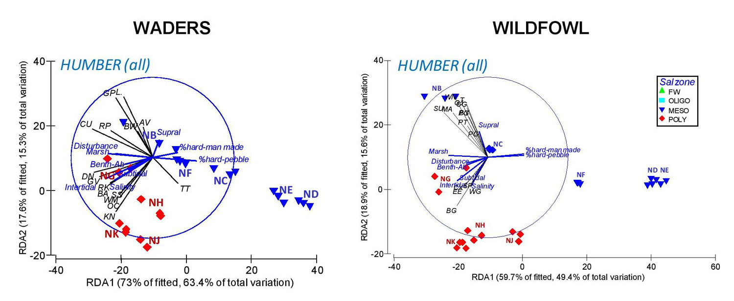
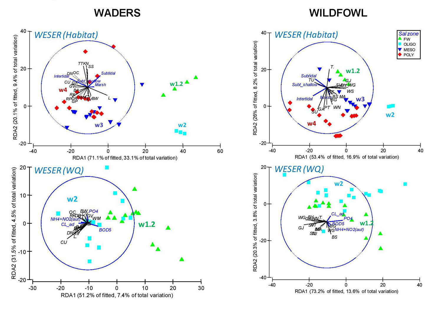
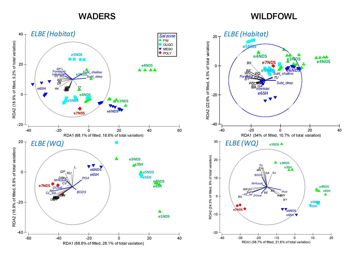

| Bird assemblages distribution and relationship with environmental variables The spatial differentiation of wader and wildfowl assemblages (in terms of overall species density distribution) within the studied TIDE estuaries is predominant over temporal changes, although a higher importance of temporal effects have been observed in the Weser compared to the Elbe and Humber, mainly due to low species densities recorded during the period 1980-1984 in this estuary. The availability of estuarine habitats (in terms of habitat area) is relevant in driving the density distribution of waders and wildfowl, especially in the Weser and Humber. The intertidal area is the most important variable influencing wader density distribution, e.g. with higher densities of species such as Dunlin, Knot, Oystercatcher associated with larger intertidal areas, mostly in the outer parts of these estuaries. This variable is also related to wildfowl distribution in the Weser, whereas marsh area is more important to this bird group in the Humber. Water quality parameters are also relevant determinants of species distribution, their effect being particularly important in the Elbe, where the salinity gradient results as the first predictor of wader and wildfowl species density, due to the general higher densities observed in the polyhaline and mesohaline zones. It is of note that, in this estuary, a differentiation in the species density occurs between the north and south banks, particularly in the oligohaline and mesohaline zones, broadly matching with the distribution of human pressures in these areas showing a negative effect on birds abundance (possibly through direct disturbance or as an indirect effect on the natural habitat availability). |
Important to know
Reports / Measures / Tools
| Report: | Management measures analysis and comparison |
|---|
Management issues
How can management targets and monitoring strategies be set for waterbirds in compensatory areas?What environmental factors should be considered in the design of a compensation scheme for waterbirds and their habitats?
What environmental variables are most important in determining minimizing or basic compensatory requirements for waterbirds?
What is important in establishing a zonation for estuaries?
What tools and guidance are available to minimise and mitigate disturbance to waterbirds?